
Ross Glen Archaeological Site

Planview of features and excavations in 1978
The South Eastern Archaeological Society put together a self-guided tour of the Ross Glen Archaeological Site in Medicine Hat, Alberta. It is regarded as one of the most important archaeological sites in the province and Northern Plains. I grew up in this neighbourhood and had no idea about the history and significance of this site.
You can view the self-guided tour of the site here. If you are interested in reading the Archaeological Survey of Alberta report on the site you can find it here.
About the Site
A portion of the Ross Glen neighbourhood in Medicine Hat is built on the Ross Glen archaeological site, identified as Dl Op-2. Three different periods of human use date back 5,000 years, although most use happened about 1,500 years ago (the Bullshead Subphase of Besant culture). Another occupation with undetermined age happened later. The most visible features were 18 stone circles, but 42 other related features were recorded. This place was home to small groups of people, separated by thousands of years.
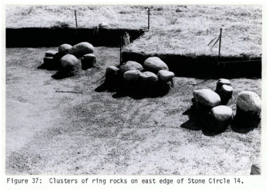
Two tipi rings revealed rock clusters around post molds. It was believed that these clusters were placed around the tipi poles when the edges were rolled up, allowing air to pass through.
An assessment by Ethos Archaeological Consultants in 1978 found the site is approximately 3.5 ha (8.8 acres) in size. Detailed excavations of 546 square metres in 1981 represented only 2% of the overall site. However, this small area yielded 45,000 pieces of cultural material!
J. Michael Quigg, who attended the assessment and led the excavation, described the site as “one of the most significant stone circle sites yet investigated in Alberta and possibly in all the Northern Plains.” The vast amount of stone flakes, fire broken rock and animal bones confirms that these stone circles were an active community, although only lasting perhaps a few weeks. Nearly all other stone circles in Alberta have very few related artifacts.
The excavation preceded destruction of the site as part of the Ross Glen Stage 5 land development, which included 550 houses and their requisite subsurface utilities.

Ross Glen Site Map
Directions
You can reach the site from Ross Glen Drive. Turn onto Taylor Crescent, then park in the cul-de-sac to the left, and take the paved access. Once you reach the main trail, a green bench to your left (North) is a good place to sit. The map shows the approximate area of the whole site.
Site Use
Indirect evidence from Ross Glen suggested that site use best fit the fall period, although minimal flora and faunal material was uncovered to define seasonality more accurately. Material remains supported the hypothesis that considerable meat and hide processing took place.
A conservative estimate based on the number of tipi rings suggests gatherings of at least 100 people, which would have included enough people to accomplish the labor-intensive tasks of surrounding and/or impounding buffalo.

Upright anvil stone
The stone circles ranged from three to ten metres in diameter, implying several different purposes.
A variety of activities took place at the site, and people stayed for long enough to create refuse piles. Tools were fashioned, improved, and discarded, made largely of local materials, although some Besant points are believed to have been brought from Montana. Post holes are evidence of a structure, likely built to support hides while they were tanned. The quantities of fire[1]broken rock indicate boiling pits used to extract marrow from the large bones. This, in turn, indicates a major kill site must have been close, perhaps near one of the visible cliffs.
Findings
The thousands of pieces of cultural material included lithic debitage (small waste chips produced when knapping stone into tools), fire-broken rock and bone, and tools, at a rate of 59 items per square metre investigated.

Significance
One of the highest frequencies of ancillary features of any stone circle site in Alberta, including fire broken rock piles, hearths, lithic concentrations, and post moulds.
The highest density of cultural material of any stone circle reported (as of 1981) in Alberta, and possibly all the Northern Plains.
For the first time in Alberta, ceramics were found directly associated with Besant materials in good cultural context.

Considerations
Unfortunately, there is no evidence of the archaeological excavations left to see. But, standing on Ross Creek Coulee Trail in the vicinity of Taylor Crescent, you are standing on thousands of years of hunting and gathering history. Have a seat on the bench and try to envision what the area looked like thousands of years ago. Why might this site have first been selected? Why was it reused over the millennia? Why is the site where it is, and not 1000 metres north or south? What can you see from the vantage point of the site (or what could you have seen)? What made this site sustainable for prolonged use?
References
J. Michael Quigg, Ross Glen: A Besant Stone Circle Site in Southeastern Alberta, 1982, Archeological Survey of Alberta Manuscript Series No 10, 1986.
Ross Glen: a Besant stone circle site in southeastern Alberta - Open Government